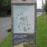
Recently, nine new trail maps (Way-finding Stations) were installed in different parts of the West Seattle neighborhood. These are fantastic tools to help people get out and explore their local community. Not only are they tastefully done design wise, they include useful information for things that you can walk or hike to such as:
 People parks, dog parks, play fields, schools, grocery stores, farmers markets, P-patches, shops and restaurants, health clinics, emergency stations for police and fire, elevation guides, and walking times.
They even highlight bus routes, bike routes, stair cases, cross-walks, streams, paved vs. primitive trails, and future trails. Kudos to the local West Seattle community for their time and effort to in designing these trail guides. These signs were created by Feetfirst and sponsored by the Seattle Department of Neighborhoods, Active Living by Design, and the National Park Service.
For businesses looking to help employees move more, developing small portable maps such as the West Seattle Way-finding Stations with local attractions is an excellent inexpensive tool to offer internally. Mapping out different routes around the business with distances for daily exercise and highlighting healthy food sources begins to open the door to the many options available to employees for activity and nutritious food selections. Making them fun will also help with engagement and usage of the maps. Think scavenger hunt morale event or weekly fitness challenges along different routes, or department cook-offs using local ingredients. There are many more ideas that can be added to the neighborhood maps, just get out and explore your local neighborhood and you will be surprised what you find from the street level rather than passing by in the car.
